| Author | Message | ||
Reepicheep |
The Q1 does not have a memory card, and I think mine keeps data through a reboot. Not really sure, as the thing has not rebooted since I got the latest firmware. Henrik, here is the fun of a track map. Recognize this route? This was you, but from about 130 feet behind. Here is the elevation profile we followed. Can't beat that: 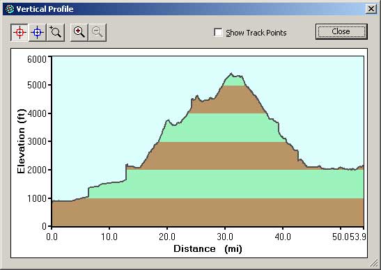 Here is the track... 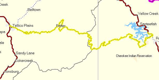 And here are the detailed tracks... there are 821 of these entries just for the leg shown in yellow above. BTW, you were speeding   Wish I were there! (Message edited by reepicheep on November 27, 2006) | ||
Court |
>>>>This was you As Dr. Henrik's attorney, I advise him to relish the cherished right to remain silent. My client was never there. | ||
Reepicheep |
In his defense, he was just trying to keep up with the *really* fast guys... (two on Harleys, one on a Victory ). | ||
Reepicheep |
OK, I checked, and sure enough to do the "rubber band routing" that I describe above, I was doing what JackB described... adding waypoints on every interesting road and recalculating. I can then drag any of these existing (or newly created) waypoints around the screen onto to other interesting roads, and the route will follow, calculating the "best" route between my waypoints. Obviously, if I have a waypoint on a particular road I want to hit, then that road will be on my route. Its a nice easy and non tedious way to have the bulk of a route auto calculated, but then tune it along all the "wiggly" lines that look interesting. And Jack is right, I would rather have my Quest 1 with this feature, then a Zumo without it. It's amazing how many GPS units are out there that don't get something fundamental like this right. Though I bet there is a way to force the Zumo to do it if somebody wants to make a hobby out of trying... | ||
Red_chili |
So far you fellers are talking road point-to-points. If this cheapskate is ever to justify a GPS, it has to cover me for those areas and uses where a map is a pain: 1) true off-roading, on singletrack and doubletrack, with the occasional unmaintained 'forest road', and 2) hunting scenarios for cross-country foot travel where topo info/orienteering is important, and 3) 4x4 use (see #1 above, minus the singletrack). Tall order? Which excels at this for ~$300-400? | ||
Soloyosh |
The Q1 does not have a memory card, and I think mine keeps data through a reboot. Huh... I guess your're right. I've had to hard boot mine once and the route was gone. Red_chili: My Quest will do that stuff with the addition of the Topo software. In fact without it you may be covered for #3 with just the City Nav software that comes with it. I got my Quest2 for $400 shipped from Newegg.com about 4 months ago. It doesn't come with the PC software, but if you call Garmin they'll send it to you FOC. Cheers Brett | ||
Jackbequick |
Reep, Nice work on the screen image snags! "If I was re-routing without adding waypoints, I wonder if that would work on the Zumo as well?" The Zumo manual says "You can add a stop to your route. The zumo gives you directions to the stop and then to your final destination." So as I read that, the rubber banding would not work there as the rubberbanding would just keep changing the location of that single "stop". For all practical purposes you cannot save routes on the zumo, only the destinations (a max of 500) as "favorites". In comparison, on the old StreetPilot 2610, Quest, or Quest II, you can save 500 waypoints, up to 50 routes, and a route can have up to 254 waypoints in it. Believe me, 500 waypoints will control a *lot* of routes. Here is a link for a download of a *.gdb file with the route of Dave's Uly ride earlier this year. If you have MapSource you can look at the route: http://users.adelphia.net/~jackerbes/Buell/daves_r ide.gdb That was a 3,042 mile ride with a lot of route variations that were purely for the joy of it all. I was putting waypoints the roads on the map in MapSource as he mentioned them in his narrative and it produced that route. And it only took 22 waypoints to get MapSource give me the route. I really want to ride the western end of that route, out there in the mountains. Maybe next year. If I wanted to do Dave's Uly ride with a zumo I could do it by storing the 22 waypoints as "favorites" and going to them one or two at a time in the right sequence. I'd need a list of the waypoint names in sequence on paper. Then I'd pull over every time I arrived at a waypoint and go to the next one on the list. And all that is because Garmin's view of "more features, newer, and better" turned out to be less capable at navigation, harder to use, and dumber in many ways. Jack (Message edited by jackbequick on November 27, 2006) (Message edited by jackbequick on November 27, 2006) | ||
Csg_inc |
One other issue is the time it takes for the unit to recalculate in the auto route mode. I have the BMW Motorrad II (relabled for more $$ Garmin 2610) that is very fast at recalcs and a Garmin 330C also very fast at the recalcs but I also have the Garmin Quest2 that is slower than cold molassis at the recalcs. It also seems to drop out sections of the detailed road maps while you are riding (always the same areas) | ||
Jackbequick |
Red_chili, On the street and highway routing, the Garmins follow "vectors" so your routes are shown as lines that match the contours of the roads. The vectors are what allows "autorouting". The software choose vectors from networks of interconnected and crossing vectors to choose the vectors that it believes to be the quickest or shortest path. That's called a "Follow Roads" route. For anything else (topo, marine, etc.) there are no "vectors" for autorouting. Any lines seen (dirt roads, trails, etc.) are just for your visual reference. These routes are called "Off Road" routes, you place waypoints to mark the routes, and the route proceeds in straight lines from one waypoint to the next. As an example, if you lay out a off road route on your PC, you'd likely place waypoints on dirt roads or trails, following terrain contours, valleys, and stuff like that for what looks like a good way to get where you want to go. Once you get out there, in the woods or where ever, you proceed from waypoint to waypoint but real world conditions will decide your actual path. Your GPS might show you to be 1/2 a mile away from your next waypoint but you might have to travel a mile to get to it. In the more "intensive" off road environments I like the rugged and waterproof handhelds for their compact size and ability to be padded and strapped in place almost anywhere. They are the go anywhere and do anything models. The smaller displays on the handhelds are okay for off road use as you are more likely to be using them at an occasional glance more then closely following detailed guidance. You need the handheld to get the easy portability, two AA cell battery power, pocketable size, etc. If you look at the MapSource Map Viewer on the United States Topo page you can see the level of detail you would get with that mapping package. The Garmin topo maps show most of the local paved roads on them too, the roads that are red in color can even be used for autorouting or "Follow Roads" routes. Plus all the major roads that are on the basemap that comes with the GPS will autoroute too. The MSRP on United States Topo mapping software is $116.65, you can find it on amazon for $80 to $100. The MSRP on a 60Cx is $482.13 but you can get it now on Amazon, after a $50 rebate and with free shipping, for $305.23 So something like the 60Cx or 60CSx (the CSx has a compass and altimeter) might be in the ballpark for your needs. The handhelds are really the most versatile GPS receivers and they still have all the navigation related features that are starting to go missing from the automobile units. You can do the automobile navigation work with a handheld like the 76Cx. It does multiple destination routing, auto rerouting, saves tracks, etc. It does all the "good stuff" for navigating. What you give up using a handheld in a car is some display size, no voice prompts (but you do have audible alarms), no MP3 players, etc. Trying to use a automobile unit in the rougher conditions is just not practical. They are not tough enough, some are not waterproof, they aren't good for very long on their built in batteries (if they have one) and can't use easily replaced batteries like the handhelds with their AA cells. I like to slip my 76Cx into the map case on my tank bag, I power it off the bikes 12V system, and I'm good to go. It also works on the ATV and I use it on boats too. It is all the help I need or want to bee bothered with. Jack | ||
Henrik |
Looks like Cherohala Skyway - not that I was ever there during that time and certainly not at those speeds ...  I still have a hard time grasping why a manufacturer would cut out features - from software no less, i.e. no additional material costs - that seems so logically targeted at the kind of mapping and navigating you'd be doing on a motorcycle. Court - who's our contact at Garmin? Can we try to get confirmation on those questions? Henrik (laying low and staying (mostly) silent) | ||
Krassh |
I remember seeing someone in one of the GPS saying they work for Garmin. Tried doing a search for the thread but cannot find it. | ||
Mainstreamer |
Jack, thanks for all your help. Your straight forward explanations make it seem simple, even to a newbie like me. You da man!  | ||
Court |
Pardon the interruption, but a bit of a sidebar. A group of Buell R&D folks were recently on their annual fun outing riding the woods of Michigan. It was "off time", not official, and they were on their dirt bikes. One of them was SERIOUSLY injured when he hit, at considerable speed, a log covered with ice and leaves. They were miles from the trailhead where they entered the woods. But, while some were fashioning a liter from tree limbs stuck through the arms of coats, another fellow found that they were only 1-1/2 miles from a highway, as the crow flies, through the woods. There were able to summon EMT personnel and tell them precisely where they'd be exiting the woods. Possibly a life saver. . he's still in tough condition a month later. Just a thought . . . | ||
Court |
Henrik: Send me the questions, I haven't had time to go through the entire thread. I'll get them answered and post here. | ||
Reepicheep |
Good point Court. I watched a Honda Minivan slide sideways head on into a Mazda 6 series sedan. Probably 100+ mph closing speed on the two vehicles. I was not the first person to call 911 on the cell phone (as I had to get the bike to a safe place and get enough gear off to make the call). But I guarentee I gave them the most accurate location for the unconscious and bleeding mazda driver. There was no question about my location. The GPS showed me exactly what road I was on, and where it was relative to other major intersections. Do you always know what road you are on? Do you always know where you are on it? In the event of an emergency situation, do you want to have to go back to the nearest street sign and remember which way is north to summon emergency help? I also have the track log from that ride, showing my speed with time stamps. It did not end up mattering, but if it had, I had a full documented history of my speed position during the entire event. | ||
Reepicheep |
When threads collide... http://www.badweatherbikers.com/cgibin/discus/show .cgi?tpc=142838&post=785316#POST785316 Looks like the Zumo will still do multi point routes. On the desktop software, they call them waypoints, but within the Zumo, they call them "via points". Looking at the Garmin site for the Zumo, they say it will store 500 waypoints. | ||
Chadhargis |
Nice track of the Cherohala Skyway. One of my favorite roads. | ||
Jackbequick |
Thanks Reep, I stand corrected on the zumo then. The zumo does do multi destination routing. I read Rhinowerx's post in the other thread and hit the online manual again. The section on Creating a Saved Route describes how to add multiple locations to the route. Looking at the online product comparison it looks like a saved route can have up to 200 locations in it. That is a lot better than the "one stop" as described in another part of the manual. It may be that "saved routes" are handled differently than a single destination "goto" route from your present location. You may have to create a saved route to get that many via points in it. But that is fine, that is the way most people would want to do that. "..they say it will store 500 waypoints..." Right, and 50 routes and a route can have up to 200 waypoints in it. So that makes the zumo about the same as the Quests and the 2610. So now the zumo really only comes up short (in my book) on trackpoint collection. On trackpoints zumo=0, 2610 = 2,000, quest = 10,000. Jack | ||
Dickc |
NUVI 350 at Walmart for $488.00... Amazon for $484.00 Dickc | ||
Rkc00 |
Just ordered the Zumo 550 for my wife for christmas. Yea right!!! She asked for the C340 but I could not resist the upgrade. Mike Long Island, NY 06 XB12X Black of course | ||
Dickc |
NUVI 350 now at Walmart for $449.99 How low will it go? Dickc | ||
Lorazepam |
seeing how the nuvi is not rated waterproof, I am guessing you will let all the smoke out of it in the first good rain storm | ||
Khollister |
I broke down & ordered a Zumo today from Anchor Express for $745 shipped. Also got a Ram ball mount that is on a tab with an 11mm hole that I can bolt onto the mirror mount since I'm using bar ends. I'm going to rig a windshield mount for the Road King. | ||
Too_tall_todd |
Holy smoke Khollister, I thought they were going for Like 1400. Where is this anchor express? I just ordered the nuvi 350. It has not arrived yet but for a couple hundred extra... thanks T3 | ||
Khollister |
$1400 ?!!!!! The MSRP is only $999 I think. http://www.anchorexpress.com | ||
Jackbequick |
The MSRP on the Zumo is $1076.91, the optional at extra cost GXM-30 XM "smart antenna" (it is actually a XM antenna and receiver I think) is $267.84. So that probably accounts for the "like $1,400" impression. The GXM-30 is a about 3" in dia., looks like a hockey puck on a cable. The on line user's manual has no specifics on mounting or connecting the GXM-30. But I'm assuming the "hockey puck" needs to be put somewhere that gives it a sky view. and that it plugs into the GPS or connects to the GPS harness. I like the looks of the Zumo, and would probably buy it without the receiver if I were going to buy it. If I was of less of a "minimalist" mindset on GPS receivers and/or it I rode something with a cavernous fairing for mounting things in and on, I might be more interested in the XM receiver. The $750 street price on the Zumo make it an expensive toy but not outrageously so. It does come with a good RAM mount and full North American mapping software preloaded to the GPS and on DVD for installation on a PC. Jack | ||
Baydog |
I'm holding out for a 276C with the SirfStar III chipset and SD card memory. THAT will get me to shell out the money. Till then, nah. I'm not buying any GPS that doesn't have the newer SirfStar chipset. The difference in sensitivity is phenomenal, and in forested areas, that's a big deal. | ||
Baydog |
Acccck! I just went to the Zumo specs on the Garmin site and I guess I just described it. Wow. Now I'm going to have to think about parting with the cash. If they'd only make it around $500... | ||
Jackbequick |
It the sales on the Zumo take off pretty good the prices will drop some more. But probably not an awful lot more. If you want a something for fairly serious marine use the Zumo does not have the marine use pages and route/waypoint/track storage I'd like to have. They are not selling a SiRF III marine chart plotter yet that I have noticed, they are all still 12 channel WAAS receivers. You really need to buy one for the boat and another for the bike Rod. :>  Jack | ||
Stevenknapp |
I use my Garmin 276C on my bike, boat, car, and snowmobile. So far it's the best of the many GPS's I've owned. I've not seen too many reasons to upgrade actually. And last I looked the used value was pretty low. |