It is likely that hurricane watches and flood warnings will be issued Tuesday along the U.S. eastern seaboard. According to the 11:00pm advisory: A west- northwestward to northwestward motion and an increase in forward speed are expected during the next couple of days.
Maximum sustained winds are near 140 mph (220 km/h) with higher gusts. Florence is a category 4 hurricane on the Saffir-Simpson Hurricane Wind Scale. Some strengthening is expected during the next 36 hours, and Florence is expected to be an extremely dangerous major hurricane through Thursday.
Due to the specifics of this storm’s potential, ask yourself: How would I need to prepare if my power was out for two weeks to a month? Some experts are predicting massive and unprecedented flooding – SEE HERE – If you don’t have to be there, plan to leave.
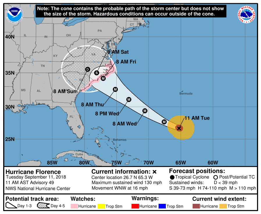
Below is the National Hurricane Center's 11pm Forecast. The dark brown is the diameter of hurricane force winds. Amber is tropical storm force winds. Note that is nearly 200 mi. across. The eye of the storm is forecast to go ashore between the arrows:
Note the rapid deceleration after the storm moves inland. If that forecast is correct, Florence will be position to cause torrential rains leading to catastrophic flooding. It is certainly possible that some location may have 30 or more inches of rain. This would cause record flooding leading to areas flooding that have never flooded before.
Right now, Florence is forecast to be an upper category 4 but being a 5 is not completely out of the question. I really like the comparison to the 2015 flooding -- only this may be worse.
In the interest of full disclosure, the storm weakened slightly in the last six hours. I'm not sure why. I believe it will regain Cat 4 intensity and be a major hurricane at landfall (I would love to be wrong).
The national media has not been covering Florence as it should but believe me: if the wrong ingredients come together, Florence could be the worst disaster in U.S. history due to:
- Winds of a strong Category 4 storm, a rare event in itself. The winds will be coming into the U.S. coast at the most destructive angle. - Terrible storm surge of 12+' - Major to catastrophic flooding due to maximum rainfalls of more than 20" (likely) to more than 50" (possible if the storm stops moving in the wrong place) causing record flooding.
Let's break it down. If you have friends or family in the Middle Atlantic Region, please make sure they are aware of all of this.
Why the Exact Eye Location Doesn't Matter (Too Much)
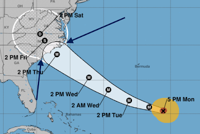
The storm already has sustained winds of 136 mph with stronger gusts. But, the diameter of the most destructive winds (known as the "wind field" to meteorologists) is growing. I am presenting the map below to illustrate my point. The wind field could be shifted north or south, so remember this is an example, not an exact forecast.
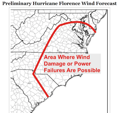
Please also note that destructive winds are possible well inland. Finally, gusts strong enough to cause power failures (bright red) could occur as far north as the Virginia foothills. Again, the winds could shift north or south aways.
So, please look at the map below. Prepare for the possibility of power failures over the entire area, and destructive winds nearer to coastal areas.
Because it is possible for rain in West Virginia to cause a river to flood in South Carolina, I have depicted the entire area where major flooding is possible.
Here is the latest 500 AM EDT forecast track and key messages for Hurricane Florence from the @NHC_Atlantic. Hurricane and Storm Surge Watches have been issued in association with major Hurricane Florence. #HurricaneFlorence #HurricanePreparedness #HurricanePrep
-- National Hurricane Center, 6:12 AM - 11 Sep 2018
Anyone in its sights, I'm on high ground in MD...spare room is open. It'll rain like hell here, but at 1500' elevation...if I flood, we all have bigger problems.
The issue with the inland eastern seaboard is...it's been raining for WEEKS. Literally non-stop - I had one day, ten days ago, when I could cut grass.
Potomac River at Harpers Ferry? Today? Already at 11.3'.
Flood stage is 10.0'.
And the storm isn't even here yet.
Fill your fuel tanks, folks. Bathtubs with fresh water. Stock up on food. I'll certainly be going through my old, forgotten frozen stuff - freezer cleaning time! Lowe's has zero sump pumps. We've had a run on Honda generators today. Lines at the gas stations on the way to work today.
It looks like the last 24h has shifted the storm slightly south, so up here we should dodge some of the winds and massive rain...but it's still going to be ugly.
Hurricane Florence threatens to unleash catastrophic inland flooding in Carolinas, Virginias By Alex Sosnowski, AccuWeather senior meteorologist September 11, 2018, 1:06 PM EDT
With the potential for Florence's forward speed to slow and possibly stall, a current forecast of feet of rain would lead to catastrophic flash flooding and major river flooding in parts of the Carolinas, Virginia and possibly other neighboring states.
In general, most of hurricane damage and loss of life occurs not on the coast, but from flooding as the result of heavy rain. In all likelihood, this will be the case with Hurricane Florence as well, according to AccuWeather President and Founder Dr. Joel N. Myers.
“There could be devastating floods well in from the coast back in the hills and mountains of North Carolina, Virginia and West Virginia,” Myers said.
As AccuWeather meteorologists have warned about since the middle of the soggy summer, any tropical storm or hurricane that moves over saturated ground in the eastern United States during the height of the hurricane season may lead to disastrous flooding.
"Strength, track and forward speed of Florence will be the major players in determining the scope and amount of rainfall and correspondingly the severity of inland flooding," according to AccuWeather Hurricane Expert Dan Kottlowski.
Brace for flooding on par with Floyd, Joaquin and other hurricanes
“There’s never been a storm like Florence. It was located farther north in the Atlantic than any other storm to ever hit the Carolinas, so what we’re forecasting is unprecedented. Also, most storms coming into the Carolinas tend to move northward, and this storm looks like it’s going to stall over the region and potentially bring tremendous, life-threatening flooding,” AccuWeather Vice President of Forecasting and Graphics Operations Marshall Moss said.
President Trump FEMA Press Briefing in Oval Office – Hurricane Florence Preparations (video and transcript) CTH - Sept. 11, 2018
Earlier this afternoon President Trump and Vice-President Mike Pence held a press briefing in the oval office along with FEMA Administrator Brock Long and DHS Secretary Kirstjen Nielsen to discuss concerns and preparation in advance of hurricane Florence.
Those in the forecast areas are strongly advised to pay close attention to local officials and heed all evacuation orders. Florence is projected to be a long-duration event for the eastern seaboard and mid-Atlantic region. Severe, possibly catastrophic, flooding is likely.
[Transcript] – Oval Office – 3:13 P.M. EDT – THE PRESIDENT: Okay, thank you very much. I’ve received a briefing from Secretary Nielsen, Administrator Long, and my senior staff regarding Hurricane Florence and other tropical systems that will soon impact the United States and its territories. The safety of American people is my absolute highest priority. We are sparing no expense. We are totally prepared. We’re ready. We’re as ready as anybody has ever been.
And it looks to me, and it looks to all of — a lot of very talented people that do this for a living, like this is going to be a storm that’s going to be a very large one — far larger than we’ve seen in perhaps decades. Things can change, but we doubt they will at this stage. It’s a pretty late stage. We doubt they’re going to be veering very far off course.
The places that are in the way and in the most jeopardy would be Virginia, North Carolina, South Carolina — that area. And again, they haven’t seen anything like what’s coming at us in 25, 30 years — maybe ever. It’s tremendously big and tremendously wet. Tremendous amounts of water.
So I’ve spoken with the governors of South Carolina, North Carolina, and Virginia. They’re prepared. We’re prepared. We’re working very well in conjunction with the governors.
I’d like to ask Brock Long, our Administrator, who’s done so well for us in Texas and Florida — we have something that could very well be very similar to Texas, in the sense that it’s tremendous amounts of water. Texas was the one that had, I would say, to this point, Brock, probably more water than we’ve ever seen in a storm or a hurricane. And it went out for seconds and thirds. We’ve never seen anything like it.
But FEMA, as you know, did a fantastic job, and a fantastic job also in Florida. And I’d like to ask Brock, if you would, to just say a few words to the media as to where it is now, what’s going to be happening, and how well prepared we are.
ADMINISTRATOR LONG: Thank you, Mr. President. Unfortunately, Hurricane Florence is setting out to be a devastating event to the Carolinas, and potentially Virginia as well.
So as you can see, they’re forecasting a major landfalling storm — Category 3 or 4 storm at landfall. The biggest hazard that we’re worried about is storm surge. That’s the primary driver of the evacuations that are underway by the states of North Carolina, South Carolina, and Virginia right now. But as this system comes in and makes landfall, during the weekend it’s forecast to stall out, lose its strength and its steering currents, and drop copious amounts of rainfall.
Unfortunately, the remnants of Gordon passed through the Mid-Atlantic over the weekend and dropped a lot of rain, saturating rivers. So, Hurricane Florence, as it comes in and puts anywhere between 20 and 30 inches more in isolated areas, could create a lot of inland flooding.
So, right now, sir, we’re supporting the governors with achieving their life safety evacuation and movements. We’re focused on mass care and sheltering. And then we’ll be focused on helping them to execute their response and recovery goals.
THE PRESIDENT: What are the chances that it veers off course and the hit won’t be so direct? What are the chances of that?
ADMINISTRATOR LONG: Unfortunately, I believe there’s quite a bit of certainty in the track forecast because the forward speed is picking up. It’s getting faster. And when systems do that, the track forecast becomes a lot more accurate. And I think the expectation needs to be set with the citizens in this area that, if you’ve been asked to leave, get out of the areas that are going to flood, and get into a facility that can withstand the winds.
Let’s set the expectations as well: This has an opportunity of being a very devastating storm. The power is going to be off for weeks. You’re going to be displaced from your home in the coastal areas. And there will be flooding in the inland areas as well.
So these are going to be statewide events. The hazards will be statewide.
THE PRESIDENT: Thanks. You wanted to show us this one then?
ADMINISTRATOR LONG: Yeah. This is a seven-day rainfall graphic. As you can see, the pink areas and the purple areas indicate 20 inches. That’s mean area rainfall; that’s an average rainfall amount. But you may see isolated amounts greater — into the 30-inch range — over Virginia, the central portions of Virginia and West Virginia. And these impacts are — they’re going to be through the Mid-Atlantic. So we’re coordinating not only with South Carolina, North Carolina, and Virginia, but other Mid-Atlantic states, all the way to Delaware.
8 PM EDT update: Hurricane watches and warnings are out for the eastern seaboard. Please continue to monitor the latest NHC forecasts and follow official evacuation orders if you are in an impact area. #Florence
President Trump’s entire Cabinet is focused on #HurricaneFlorence. At Interior the USGS is deploying hundreds of stream gauges, USIndianAffairs is assisting Tribes w/emergency prep, & NatlParkService & USFWS are prepping/closing sites to prevent damage & injury.
I subscribe to Surfline, an online resource to check wave sizes at different surfspots locally (I live in So Cal and surf). The forecast for So and North Carolina is for 50 ft seas. That’s massive on top of a 15-20 ft storm surge. Outer Banks will most likely get smashed.