| Author | Message | ||
Snakebreak |
So I have free place to stay next weekend if I can make it to Death Valley. My plan is to stay low and not cross any mountain passes. Anyone know the roads in Eastern Oregon? I have a choice around Pendleton OR to take 395 south or to take 84 to 95. I want to have the minimum amount of snow. Also if you take 395 you leave to take 205 south. Any gas on this route? Google maps say it takes 3.5 hours to go 136 miles from Burns to Denio Junction. This sound interesting, but if there is no gas at Denio Junction it is a no go since the next town seems to be out of gas range. Any suggestions are welcome. | ||
Idaho_buelly |
There is no fuel @ Denio Jct,just a set of crossroads (Denio Rd. & Hwy 95)..All of those roads leading to Winnamucca are forever straight and all high desert...Hope this helps....Tim | ||
Waterman |
Snakebreak you're joking, right? US 395 out of Pendleton has about 5 or 6 passes over 5000 ft. till you get to Burns Or. I-84 to US 95 down through Winnemucca is probably the better way .But...you're still over 4000 to 5000 ft most of the way down south to Death Valley. The only low road is probably along the Pacific Coast. I'm sure there's gas at Denio http://en.wikipedia.org/wiki/Denio,_Nevada It's the only speck on the map in that part of the country.That's the only route (205) that I haven't traveled to the northern part of Nevada from Eastern Washington. US 97 Bend Or.to I-5 though Central California to Bakersfield then east over 58 would probably be the only I'd would even think of going this time of year. Good Luck and keep warm. Waterman | ||
Xbimmer |
US 97 Bend Or.to I-5 though Central California to Bakersfield then east over 58 would probably be the only I'd would even think of going this time of year. +1. Burn some Interstate then poke around closer to your destination. Get a ten-day weather forecast before you do your planned route maybe. Bend is high desert and gets snow too, and anything around 4000 ft can change quickly even through April and May. Death Valley is amazing and a great ride this time of year, but you'l need to do some climbing before you descend into there. | ||
Snakebreak |
That is helpful. I have never been on any of those roads. No Waterman, I am not joking I am just crazy. I was looking at weather for the places I could along the 84 to 95 route and it doesn't look like snow, with temps in the high 30's. My thoughts are if I can get down there I can Ulysses (in the Greek sense) back along the coast. But now you have me thinking I should blow down the Columbia to the coast and down to Bakersfield. Idaho_buelly you are over by the 84 95 Junction aren't you? Is there snow on the roads? What do you think of the run from there down to Winnemucca? | ||
Idaho_buelly |
Idaho_buelly you are over by the 84 95 Junction aren't you? Is there snow on the roads? What do you think of the run from there down to Winnemucca? The roads are all open right now to winnemucca,but that is all high desert,can change quickly w/ a storm...Roads are pretty boring,long and straight and is only 55mph thru Oregon,then 70mph as you enter Nevada..On the way are some crossroads that has nothing but signs, but the actual town of Denio probably has fuel as Waterman pointed out..I thought Denio Jct. was the crossroads?....Definately some wide open spaces!..They watch that stretch thru Oregon for speeders..Seems to take 4-4.5hrs from Boise to Winnemucca consistantly ...Have a safe trip...Tim | ||
Panhead_dan |
I wouldn't worry too much about snow now unless there's a freak storm. If so, it won't last. There are weather cams on some of those passes on the odot site. You will see rain. Like stated above, check the weather before you leave and plan your route by that. You are rolling the dice on the return trip. I'm in Hermiston if you need anything on your way through. I would roll hwy 97, depending on the weather. You can make fair time on 2 wheels on that road. | ||
Panhead_dan |
I rode down to Frisco a few years ago in February on 97 to Weed and south from there. One high pass to cross. Hit it in the middle of the afternoon and ya got it made. | ||
Snakebreak |
A short update. None of the routes (even I 5) was without snow. I ended up going almost all the way to San Francisco on 101 before I could go back east. Looks like I will be in Death Valley tomorrow. So far it has been 1087 miles through about 50% rain. (My bags don't leak.) I have done the Columbia River, South Oregon Coast, the Redwood Highway, and Napa Valley. Talk about some diverse terrain. The redwood highway is great riding, I assume it normally has cars on it, but not many today. I'll post pictures when I get back. | ||
Panhead_dan |
I can hardly wait to see the pics! | ||
Snakebreak |
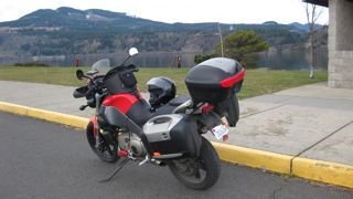 This is Hood River Oregon 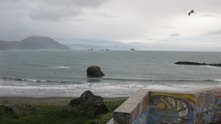 Made it to the Oregon Coast for Rain. 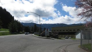 Snow Just above Highway 101 in California. 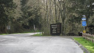 Went through the Redwood Forest. 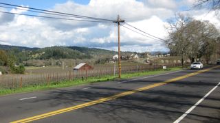 Napa Valley by Mistake. 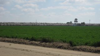 Smelling almond Trees on the Rocketship south 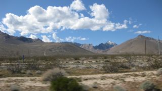 The Mojave Desert 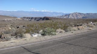 Great Twisties on the way down to Panamint Springs. Pictures of Death Valley are to come- switched to movie mode by mistake. | ||
Waterman |
WOW You made it to Death Valley. I'm totally impressed. Stay safe and keep us posted. Waterman | ||
Snakebreak |
Thanks Waterman, I probably wouldn't have gotten here without your suggestions. I would still be poking into the Sierras. Here a pick for Dr_Greg. Big yellow elk by the side of the rode in Oregon. Sorry for the bad picture.  Going to Leadville and some old mining towns today. |