| Author | Message | ||
Sportyeric |
Just to get it out of the way: Buell content: none. Riding bud, Jim, was supposed to take the S1 but, since it was a camping trip, he sent his stock red bodywork to be painted silver to match the tank, rather than screw up the paint on the carbon fibre with the expensive paint job. Unfortunately, the painter didn't have a good grasp on the time line. So our story involves only the Sportster, which I like to think is almost an honorary Buell, and a ZRX. What the story lacks in Buellishness, I'll try to make up for in wit. If Sportster stories take up to much bandwidth, Blake, just ask me to butt out. North from Vancouver up the Sea-to-Sky Highway. An auspicious start as we left the meeting place. Waiting to pull out of the Mcdonald's driveway, we catch the attention of a big beefy guy at the bus stop. He stares at the bikes for a minute, realizes that our view up the road is blocked, so he steps back a pace to clear our sight line. A good sign to see consideration from a bystander right at the very start. Mid morning traffic is surprisingly light so we have a good rip up to Squamish. The usual back-to back, slow-to-35mph-posted corners (metric conversion as a courtesy to the majority). High light of that leg: We overtake a 1/2 ton delivery van on an up-hill sweeper with a passing lane. Jim squeezes by him on a right hander at over 90mph and I cannot get by! The crazy bastard is just wailing, drifts into the left lane a tad but he was already over my speed for the corner and pulling away from me. In a delivery van. Nuts! Turns out it wouldn't be the last wacko in a cage to out-do us. Through Whistler with a care for the cops and on to the Duffy Lake Road. We leave the Pembina service station with a couple of bikes ahead of us, a newer GRX750 and an old KZ650. The GXRer rider doing a stylish butt hanging but not really making much time. My shoulders are getting tired with the clip-ons at this speed as I wait for Jim to pass them on the early flats and, later, ask why he didn't. The answer: he wanted to smoke them going up the switch-backs. And we did. Getting into full race mode to leave em behind and Jim's luggage( two Thermorest mattresses) does a bail-off at 60mph. We stop to repack and I have a smoke and a stretch. Ten minutes later, we set out to reel them in, with 40 miles to do it. Jim gets em just before Lillouette, while I get stuck behind them on a nice set of hairpins as the road descends to town. The 80 degree heat that we started the day in has, predictably, become over 100 in Lillouette, so we cool down at Mugs and Jugs with a pint. Now Lillouette is a weird little town. Mostly native Indians, one street about a mile long. Everyone stops at the dive right at the beginning of town, where the tables still have red terry cloth covers and there's a possibility of at least spectating a fight, inside or out, most any time of day. Mugs and jugs, on the far side of town, is a new effort, upscale but so well hidden only the locals would know its there. One of those locals sat at the table next to us, wkich was serving double duty as a Ms. Pacman video game. Remember those? So we get to talking and he offers that he's the town champ at Ms. Pacman. Even got off a DWI because of it. He went before a judge "who was also a tippler" and got the bartender to testify that he had, minutes earlier, set an all time high score on the game. The judge recognized that it is a game of progressive difficulty and that if he had acheived 100,000 points on Pacman, he couldn't have been too impaired to drive. Case dismissed. Of course the police followed him around for a few weeks and nailed him another time successfully. Such is life in a small town. The Pacman defense. | ||
Sportyeric |
Through rolling hills in 90 degree heat to Lytton, north on the Trans Canada Highway for twenty minutes (the only red line on the map that we see for four days) then blistering through gulleys and arroyos(?), Pondorosa country, from Spense's Bridge to Merritt. A roller coaster of a road, with generally nicely-banked corners and a few rises-followed-by-90s that we know well enough to not need a change of shorts. (Not like the first few times.) Gatorade in Merritt, another 20 mile drone on the heavily policed Coqahalla Connector, then south from Aspen Grove to Princeton on what had become our favorite road. Gentle sweepers with the occassional slow-to-30 set, past a series of lakes where all the fishermen and swimmers could only rejoice in the marvel of a V-twin throttling up to redline. We should charge admission for that! At Princeton we add a new road to our repetoire, heading north east to Bankier and a friend's lakeside property, where we had an invite to camp and burn the firewood. Black thunderclouds loomed ahead after twenty miles, with another 10 miles to go. Too close to not go look so we procede, against my better judgement. We actually caught up with wet roads but missed the rain. Feeling lucky, as the breeze was blowing it east. Unfortunately, the cottage-country general store/restaurant had closed the restaurant section hours earlier. With 350 miles on the day, and the sun setting, we made do with a purchase of hotdogs, buns, and (lacking a can opener for anything more suitable) a tin of smoked oysters. Strange campfire food, that, but pretty tasty! A beautiful view of the lake as the sun set. A six-pack or two of beer. And we're done. 180 miles from home but 550 miles logged. Or should that be flogged? Woke in the morning. Packed up the gear. Hit the start button. CLICK! A two year old battery should have been replaced. Boy, do I feel stupid. The slope off the property to pavement is absolutely un-do-able. We search around through the scap heap from a pumphouse recently built and find a short piece of 14 gauge wire. Amazingly, it offers enough amperage to boost off the Kawi, but smokin'! The Old Yale Road runs on the opposite side of the Hayes River for 25 miles, parallel to the #3 highway , which is pretty twisty itself. This old highway has a posted limit of 35 mph, with corners signed at 20. We don't pay any attention to that. What a roller coaster! A gas stop at Keremious reveals that I've scrubbed off the last of the "chicken strip" on my new Bridgestones. Yee haw! North from there: the Green Mountain Road. Running parallel to Highway 97, this heavily treed two lane twist-fest accesses Apex ski area and an Indian reservation. A respectful speed through the reserve town and no-one else is around to care. Another of BC's absolute best roads. OK, I lied. Main highway along Okanagan Lake to West Bank, where the highway crosses the lake to Kelowna and we don't. Instead, we terrorize the Westside Road. Scary high along the hills skirting Kelowna. Lots of weird corner combos with a 500 foot drop to the lake and no guard rails. I pass a tree ten feet off the roadway, leaning 20 degrees, with a bark scrape at road level about twenty five feet up it's trunk. Hope it was a car, not a bike, that put that there. First bad pass of the trip: closing on a pick-up and a sharp blind left. Think I can make it. Get alongside and decide to jam, almost standing it up on the front tire. Truck brakes at the same time, to let me in, so I go again but totally feeling stupid. Hope he turns off before I have to gas up again. Black clouds ahead again. Doesn't look good. Mercifully, we reach Vernon and head south-south east, skirting the thunder clouds again. From now on I shall no longer be called Sportyeric. My new name shall be "Dances-With-Storms." | ||
Ferris |
hey Sport.....oops, Dances-With-Storms, great job! i've been up there on some of the roads you describe a couple of times on the Border Raids (Lillooet is indeed an interesting place...), sure miss the cool scenery and the friendly Canadians. nice work, sir, any pix to go with?  write to lean, FB  | ||
Sportyeric |
Ferris. Good to hear from you. We continue your legacy with the Border Raid. In truth, the Duffy Lake road is getting a little old. Pretty choppy. In fact, I blew out the oil seal on a rear shock this trip. Strangely, it doesn't seem to have affected the handling. Maybe I'm to unsophisticated to feel the difference. I may have to re-mount the stock ones, although we are midway to installing Jim's old ZRX shocks on my ride since he just sprung (pardon the pun) for some after-markets, Olin's, I think. Pics I will have to find a scanner for. We've got a beaut from day four. Correction to my previous post, that would be 550km (about 350 miles.) | ||
Sportyeric |
Continuing with day two. From Vernon, we take #6 to Needles, a nice country road that's straight enough that there's no urge to go flat out yet winding enough that we don't get bored. Just grooving on wooded two-lane blacktop. Stopping at Lumby for a pint, we notice a ghost car with a victim as we double back to get gas. Must have been haunting the slow-to-town-speed section. Only a miracle that he hadn't got us, as we tend to get velocitized and find slowing to town speed means slowing to legal highway speeds. By the time we'd gassed up and drove by him again, he had another victim in the same spot. Lucrative territory! My main fear on this leg was that the bike wouldn't start to depart the Needles ferry, though it had been fine since starting in the morning. However, it would have been a huge push uphill just to get off the boat. Fortunately, it fired right up. The morning problem seemed a temporary glitch. Home for the night was Nakusp, at a campsite Jim knew, right in town, which offered the advantage of pubbing all evening and not far to walk home. We elected instead, however, to ride the quarter mile to the main pubcrawl section, for dinner there and beer to go. We took a patio seat to escape the hideously loud band inside (as did everyone else there), but got chased inside by a huge storm cloud that started to let loose. I was regretting having paid already for the campsite, as it looked like a night to play the motel card. Amazing weather between mountain valleys. There had been clear sky when we road to the pub and pitch black clouds now, an hour later. The rain had just ceased, or paused, at least, when we left. Out at the bikes, Jim says,"Don't look up." I'm expecting the worst but instead raise my eyes to see stars. Clouds over the mountains to both sides but clear above. Impossible that it would hold so through the night but it does! Dances-With-Storms! Not so lucky with the battery, though. Borrowed cables get it running again. The service station lady is nice enough to let me gas without shutting down. Bless her heart! Lunch at Nakusp. We picked the restaurant at the top of the main road for the best push-start possibilty. Turned out to offer the best beef-dip I've had had my life. Plus the bike started. One more ferry: Balfour to Kootenay Bay. 45 minutes of fretting and she fires right up on cue. The nice thing about ferry travel is that bikes always get let on, without line-ups. Unfortunately, since we get stuck in the unused corners of the deck, we aren't the first off. In fact, most of the boat gets off before us. Since the road on this side is rated by "Destination Highways" as the BEST motorcycle road in the province, we kill time with a pint at a strange, German owned hostel just up hill from the ferry. The style and ambiance reminded me of European owned hostels I've visited in Guatamala, with the deck built around trees rooted ten feet below. This is the second time I've had a run at this road. The last time, four years previous, it was wet and unremarkable. My memory of habitations along the road (and therefore driveways) was not strictly correct. There were some stretches that required prudence but they were well spaced out. A nice road, slightly winding, lake to the right for nice views, but still not THE BEST, to our minds. Crossing the US border at Creston goes well. I was concerned that new procedures would require more ID than a driver's licence but no prob! Also no need to search us for any of BC's number one agricultural product, for which this region is particularly well known. No problem expected there but I didn't want to have to re-pack a bunch of bags. At this point an argument ensued about routing. We were aiming for the Highway To The Sky (or some such name,) which runs over Logan's Pass through Glacier National Park, Montana. The direct route there I remembered from our previous Montana trip as being rather boring. That same trip, though, we had encountered on our way up out of Idaho a nice twisty road and, more importantly, a bar where the waitress, in 90 heat, would soak unsuspecting patrons at random with a SuperSoaker. Even better, one such patron got the squirt gun and soaked her liberally in just the right places.  It had looked like such a fun place that I had wanted to stay but it didn't fit our time-line then. It had looked like such a fun place that I had wanted to stay but it didn't fit our time-line then. It did now. I thought we would find the place as we approached Sandpoint or maybe Coeur d'Alene (which I've always thought has the most wonderful name.) Jim was persuaded that the route was worth taking but maybe wasn't as enamored of the bar as I was. Also, he felt it was further south, although still within reach for the night. Jim turned out to be right. My navigating skills have always sucked. South of Coeur d'Alene, following the shores of the lake blessed with the same name, we found what Jim feels is the best road of the trip. Second gear, sometimes third, along a wooded twister through cottage country again. Being Sunday night (and early in the seaon) everyone had gone home from the weekend and we had the road to ourselves for a scrape fest! At the town of Harrison we discovered the bar I was searching for. "One Shot Charlie's." I wanted to ask the barkeep if Charlie was a good shot or a lousy lover, but, sadly, it was boarded up and out of business. Even more sadly, the other two pubs in town had already closed their kitchens! We would have to return north, a thirty minute drive we were told, to an establishment that was still open. Being the third day of 350 miles, we weren't really in the mood, but then the barkeep specified that it was eight miles away. "I thought you said thrity minutes," says I. "Well, it's a windy road," says she. "We know," we say with smiles, and head back up the same fun-filled roosting grounds. A decent dinner is obtained and back we go again to the campsite beside One Shot Charlies. As we stop in the campsite we notice the stiff wind coming off the lake and decide our stay would be better at a State Park site four miles BACK UP THE ROAD! How many times can we flog this road before someone gives us a talking to!! The campsite is deserted but for us. Now, one of the reasons for the camping was not so much cost as the social factor. Fellow campers to chew the fat with, rather than holing up in a motel with the TV on. In hindsight, there was so little of that, that I would probably vote for travelling light next year. In any case, we found company in a twelve pack after I so cleverly parked by bike at the top of the hill by the camp hosts, in anticipation of continuing morning starting troubles. And so, killing beers and brain cells looking out over Coeur d'Alene Lake, we patted ourselves on the back for the chioce roads we had covered to the end of Day 3. | ||
Sportyeric |
Day 4. South from Harrison through roller coaster roads through the farm lands. I'm amazed that Jim had remembered the lay of the land from our romp through four years ago. Either he has a great memory or I did too many drugs in my youth. Ripping through 30mph corners for an hour or so, then a short straight in which the on-coming traffic consisted of a huge piece of machinery taking up 3/4 of the road. Glad we didn't encounter it on a corner. The picture that thought brought to mind was of the flat deck trailer on a corner at Deals Gap, with a couple of Big Twins in the ditch (posted elsewhere on the Badweb.) A late breakfast at a "country kitchen" little place, made memorable by my selection from the menu: Green eggs and ham. Just as described, scrambled eggs tinted a brighter green than my bike. Glad to have blown the hangover away with the morning ride. Got a picture, but sorry, it's not been scanned. Choices of roads east to Montana were either north to Sandpoint, then east, which we had done the previous trip and found boring; south a ways then onto another major highway; or due east through Avery to St. Regis, Montana on a road marked in black on the map for 100 miles, then gravelled for 15 miles at the end. Seemed a reasonable trade-off, so away we went. The road was fantastic. A narrow valley following a river for 60 miles or so to Avery, which is basically a gas station/convenience store and little more. Interesting decor there. The front porch was plastered wall to wall, and ceiling, too, with Polaroids of guys in cammo posing with the cut off heads of their deer. Yuck! I felt like Ace Ventura in the study. On the plus side, the interior was decorated with posters of Budweiser girls in bikinis. In response to our queries of the road ahead, the store clerk said that the pass had been closed by a foot and a half of snow a while back and she didn't think anyone had been through from there yet.  Since the day was so hot and sunny, we decided to trust our luck and continue. (The alternative being to re-trace our route the 60 miles then south or north another 60, then east again.) Following the same river, the road traced every curve of the river. Unfortunately, Jim had a little trouble tracing the same path and did a bit of dirt tracking between huge boulders on the backside of a 25 mph curve. Just a brain-fart, cause I was right behind and got around it fine. Oh well. Didn't go down. No harm done. He gets to continue the lead. Two corners later and he's doing it again! Worse, I follow him in. This time, there's a flat gravel shoulder of decent width. Jim makes it all the way to the grass but I scrub off enough rubber to stay off the greenery. Still just brain farts but we decide I should set the pace. Good call. Glad we got the off-road stuff done early. Four corners later, a decreasing radius left-hander has no shoulder and no ditch, just a four foot drop into the drink. I've been cautious enough to be able to wrestle through the last of it, with about an inch of pavement to spare. Further caution combines with an increasingly bumpy road to make the next 30 miles a bit of a chore. The valley tightens and the road turns uphill as we wind our way to the summit of the pass and snow is beginning to feel a little more likely, though still improbable. The crest, and the Montana border, arrive rather unexpectedly. A sign points to a State Park (or something) to the left and the road widens to a large circle. The glance towards the sideroad distracts me from the road geography and I re-focus to find that the circular clearing ( like a small parking lot) ends directly ahead of me with a drop down to a treed infinity. The Montana road arrives at the clearing from hard on the right, without any regard for a continuity of the Idaho section. "Let's build a road over the pass. We'll meet here." Throwing the bike to the right would be the usual proper response, but for the fact that a foot and a half of snow was in the way. So we circle left and re-group. Being Canadians, of course, it's not an insurmountable problem, especially since someone had run a 4X4 through the drift, which seemed to be (and was) only a few hundred feet long. Pictures, Ferris? You want pctures? 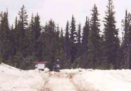 | ||
Ferris |
i have two words for you: IN SANE!!!!!!!!!!!!!! ok, ok, here's another word: COOL!!!!! that white stuff on the ground, i think i read about it once, maybe back in school or something :-) good story! FB | ||
Grizzlyb |
Sportyeric, This is major COOL. Got trapped by a snowstorm once, up in the Alpes. But the BMW GS is built for this work. To do this on a Buell is AWESOME mate,  Grizzly (FFF) | ||
Sportyeric |
Sorry, Griz. Couldn't have made it through there on a Buell. That's a Sportster.  That's why they call me Sportyeric. That's why they call me Sportyeric. Ah. And I should credit Lorraine for scanning the photo so I could post it. |