| Author | Message | ||
Reepicheep |
There is (to me anyway) as a motorcyclist a critical distinction between two different types of navigation systems. The first, which I'll call a destination only navigation system (DONS), simply lets you pick a start and an end point (and maybe if you are lucky a waypoint or two) and the DONS then picks the route that will be used to get you there and plots it. The second, which I will call a route adjustable navigation system (RANS), lets you pick a source and end point, but also lets you have complete control of the route (which can be initially auto calculated then later adjusted) used and tracked. DONS are easy and a dime a dozen. Any cheap Garmin, Google Maps on a smart phone, Nav Free (smart phone or tablet that lets you cache maps ahead of time), and my current favorite Waze (now bought by google, and which integrates real time road hazard alerts and traffic pattern based routing). RANS (Route Adjustable Navigation Systems) are much harder to come across. The high end ($300 and up) Garmin and Tom Tom systems can do it. I'm not sure any smart phone systems can do it, though Google is edging very close to it, and I've heard Navigon kinda does it if you layer up a pile of hacks and duck tape. The easy and obvious way to get a RANS is to spend $300 to $600 on a Garmin Zumo or a Tom Tom Rider (or whatever they call it now, somebody correct me). But let me introduce a new class of navigators... not a DONS (Destination Only) or a RANS (Route Adjustable)... I'll call it a MOLF.... Magic Orange Line Follower. A MOLF differs from a RANS because it doesn't pretend to be a full navigation system that you can drop on your lap and use to plan a coast to coast trip. You do that planning on a "real" computer, with a great big screen, a proper mouse, gigabytes of maps, quad core CPU's, and many many pixels. Once you plan the route there, you transfer it down to your MOLF, and turn the MOLF on. The MOLF knows where you are, knows where the orange line is, and shows you a simple map showing if you are on it or not. The MOLF also has some nice visible panels when you are on the route that simply say "you will have to do something different in X miles", and "The thing you have to do is this". For example, you will need to make a hairpin right in 2.3 miles. It's like an old enduro strip chart, but one that automatically stays in perfect sync with your location, and one that can adapt if you have to go offroute (pointing at least to the direction of where the orange line you are off of went). For a car, I just fire up my DONS, punch in the address I want to go to, put my coffee in the cupholder while I turn on the heated seats and crank up the stereo, and I just drive there. In a motorcycle, a DONS (destination only) will pretty much ruin every trip, as it does exactly what you don't want to do on a motorcycle, which is hit every freaking chunk of mind dulling superslab anywhere near your route. A RANS solves that problem, as you can make a route, then tweak it to follow all the neat little twisty middle of nowhere bits, and (a) not be lost but (b) not be subjected to stupid sections of superslab. But a RANS is $300 to $700... And a $500 RANS tries to do ***so*** much... bluetooth XM radio, full mapping, full recalculation to address every perturbation. On one hand it empowers you to go deep into road hinterlands you would never have been able to follow before, but on the other hand, it sucks some of the adventure out of it. Enter the MOLF (Magic Orange Line Follower). It is a simple device. You turn it on, and you follow the orange line when you want, and ignore it when you want. When you glance down at it, you aren't looking to see every jot and tiddle of every road and address... you are simply looking to see "how long can I really enjoy this view or railing through these turns before I have to think about my route again?" It's like having a map route in your head for those of us that can't keep a map in our head. DONS are great if you are lost and just want to get home or to gas or to your next stop for the night. RANS can be a DONS or a MOLF, but they are expensive and can become a distraction. There is a place for a MOLF on a motorcycle that is a current real gap in the industry. A $50 unit that is weatherproof and durable and that doesn't try to do everything, but that does a few very special things really well. There is actually a solution to the MOLF problem if you don't mind the duck tape and bailing wire route... a used $50 Garmin Quest 1, and maybe some other older units. It hits the price and capabilities point, but fails in the "simplicity" space. So if you are willing to overcome the complexity hurdle, it will work. The purpose of this thread is to document how to "overcome the complexity" and use a $50 Garmin Quest as a MOLF, and maybe discover what a new MOLF should really be and if it really has a place in the motorcycle world (I think it does). If you have other MOLF options, please jump in. | ||
Reepicheep |
So, as hinted, the MOLF I am going to dig into is the Garmin Quest. The QUEST was actually a RANS when it was released back in 1920 or so. It was a $300 to $600 unit. So it has all the technology (probably implemented via vacuum tubes) to also be able to be a MOLF. As a modern RANS, it is a joke. But as a MOLF? The Quest can still be a damn good one. But there are other problems with the Quest. If you do a search for a local "thing", odds are you can drive in circles and find it before the Quest does. The screen is *tiny*, and it can only hold a state or two worth of map data. The internal antenna was a stupid design from the start, and even when it hasn't been ripped off, it will fail normally eventually anyway. And the "real" powered motorcycle mount is great, it can cost more than the GPS does these days. And the Garmin DRM (digital rights management) combined with old maps and Garmin products and crappy Garmin support for them can make an otherwise nice unit a paperweight. But if you are patient, these obstacles can now all be overcome. | ||
Reepicheep |
First, the easy one, deal with the antenna. The built in one will work for a while, then half work for a while, then just go away. But there is a port on the back of the unit for an "external antenna", and these antenna's are readily available for $10 to $20 on amazon and ebay. Buy several, as they take time to ship, and the wire will eventually break. The connector you need on the antenna is an "MCX" connector. Right angle ones are harder to insert and remove, straight ones are more likely to get whacked and broken. Pick your annoyance. Cable length is also worth considering, most have longer cables which are overkill for a bike. But they don't hurt anything either. The good news is that the external antenna, even the stupid cheap ones, work far better than the internal antenna ever did anyway in terms of finding and holding a signal. So get a few antennas, and you have solved the first problem. | ||
Reepicheep |
The next obstacle is mounting it and powering it from your bike. Just mounting is easy, a basic cheap RAM mount setups are brilliant, and a passive snap in cradle is like $10 or something and will solidly hold the unit. And the Quest, being old school with a weak CPU, will actually run 10 hours plus straight if you have a good and charged up battery (replacement batteries readily avilable if the original is worn out). It does this quite cleverly, it can be configured will turn off the backlight by default (which is fine for daylight) and pop the backlight on when something important on your "magic orange line" is about to happen (like a turn). So again, it is a brilliant MOLF unit. If you do want to power it from the bike, there was an original garmin motorcycle mount that is also fantastic. Lock in clips, great contacts, easy in and out, bolts right to a RAM ball or other setup. Weatherproof and durable (I only managed to kill one by doing a stoppie into the side of a Corolla at 15-20 mph). Mirrors hit first and more or less evaporated, the Quest and mount hit second. Quest still works great, the mount was more or less extruded out the side. But that mount, if you can even find it, may be $100. Which kinda takes the fun out of a $50 MOLF, and puts you closer to "might as well get a RANS" territory. There are other options. The cheap plastic RAM clip on unit actually has a space to mount the plug part, and you can pull it off the car or wall adapter that came with the Quest and reuse it. You will need to come up with a 5v regulator (easy enough) and cobble it all in, but it will work. Well, it will work for a while (measured in years, but finite). Eventually things get dirty and worn and worn and fails, but it will last a long time. And thinking now, I bet if you put *another* connector in that wire to that cradle, and used that wire to connect and disconnect the quest day in and day out, and just left the quest in the cradle all the time, that hacked connector might last forever. Next would be hacking the case. I have a Quest that I will volunteer to try this with. I'll drill through the back of it, run a wire out of it, and just power it that way instead of those slick but hard to interface with exposed gold contact pads. I'll let you know how hard it is and how well it works. I tried hacking a power feed from the mini USB port already on it to the charging system, and it actually worked, but it was pretty difficult to do, and it leaked power when not connected. I could refine it, but I think a separate hole and wire is probably a better hack. Don't try to solder directly to the gold pads. I tried that with a broken quest, and by the time the pads were hot enough to take solder, they melted the surrounding plastic and dropped away and made a mess of things. There used to be Garmin cables that were just the connector part that would bolt to the RAM cradle. They were pricey and hard to find. I never did find anything that would work well as a hacked together alternative, it needs to be spring loaded pins with the right spacing. Theoretically possible to fabricate, but annoying in a lot of ways. I should take a trip up to the magical third floor of Mendelsons again and see if I can find a pallet of old B-52 connector cables or something that can be chopped up to create one. If you can find the motorcycle mount cheap you are golden. The battery only setup will work fine if you travel 10 hours or less at a time, and don't mind charging it overnight, and maybe put in a fresh cheap LiOn. Hacking your other power cradle will work for a year or two easy, and by then there may be other sane MOLF options. And I bet it won't be bad to drill a hole and run a dedicated wire that would be easy to repair / replace if it dies. So lots of options here, it will just take a little work. | ||
Reepicheep |
The next obstacle, which was the real deal breaker for a long time, is the stupid Garmin DRM (Digital Rights Management) encumbered maps and the stupid Garmin crappy customer support to let you use them. It was really stupid, in a lot of stupid ways. You would buy a map, and it would come with a CD and an unlock code sticker on the case. You would install the CD (if it wasn't scratched) which would install the mapsource program and your map set. You would then have to manually "unlock it" for your GPS. Even brand spanking new, this was a mess, and failed as often as it worked. For example if you got a refurb'd quest (which there were a lot of, due probably to the stupid antenna thing), the sticker never matched the serial number of the unit anyway, and wouldn't work. So you would be calling Garmin tech support to get some magic incantation that would let you use the maps you purchased on the device you purchased. Now add a few years... the original CD, which may have been made for windows 95, won't even install on your Windows 7 system. Not a chance. And it was probably scratched or cracked long ago anyway. So you don't have the media, and even if you did, the unlock process barely worked when it was new and now is an exercise in frustration. And the stupid maps are now about a decade out of date anyway. Buy a new one from Garmin? They won't even sell you one, they stopped making updated ones of the Quest 1. They might sell you the "newest" old version, but it will cost 2x what the GPS is worth in the first place. This is where this whole MOLF "quest" used to come to a flaming sliding sideways end. But then Frank (Froggy) mentioned that OSM (Open Source Maps) has a Garmin map file creator / installer. These maps aren't perfect, but neither is any other map. And on the other hand, they aren't bad either. At least not in my area, I found one thing they had right that Garmin (Navtech) has wrong, and one thing they have wrong that Navtech has right. When I went to some "middle of freaking nowhere" spots in KY, they had all the cowpaths that I knew were there. So I can't say it's perfect, but I can say it is good. The data is open source and crowdsourced, so if you do come across a road you don't see on your map, you don't have a problem, you have a new adventure ahead of you. Like a magic map that will draw itself as you go places, *you* are the first person do discover, explore, an share with the community. Just ride it, then go home and upload your track. Best, the maps are "free". Not just free as in "free beer", which is great, but free as in "nobody can tell you what you can't do with them", which is *really* great. I have successfully pulled these maps down, pulled them into both Mapsource and BaseCamp, and pushed them into the Quest, and I see the data on the screen and it looks good. I have more exploring to do here, and there may be a couple warts, but it looks better than I would have hoped possible already. | ||
Reepicheep |
MOLF example modes... you have to find the right magic settings to get the quest to look like this, but here are the two modes. The first is "stop looking at your GPS and enjoy the ride mode". You look down just long enough to get a sense of what you have to do next, and be reassured that you don't have to worry about it for another X miles or X minutes (your preference). 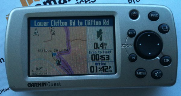 The next screen is when you actually have to do something. You get a flash preview of this screen (with a beep you won't hear on a motorcycle) .5 miles before you do it, then the Quest will switch to this mode automatically when you are within .2 miles of it and you stay there until after you do it. This is the "you should be paying attention to where you are going now mode". 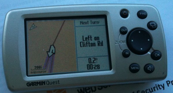 Again, the GPS switches automatically between these two modes as appropriate. That top screen can say .4 miles like it does here, or it could say 30 miles if you are on one end of the Cherohola Skyway and you have a long line of twisties to enjoy in front of you and no turn offs to make. So this isn't a RANS, it is just a tool for following the magic orange line (which is actually pink, but pink makes a worse acronym). (Message edited by reepicheep on October 31, 2013) | ||
Reepicheep |
Oh, and I just got Basecamp to download a route as well, and the quest is simulating driving it, and it looks perfect so far. I haven't tried to use basecamp to send an OSM map yet. | ||
Schwara |
Thanks for posting all this Reep. So far I've been happy enough to just playing with Navigation (Google) and Waze and I just ignore the thing when I get off the prescribed path. I would love to have a solution that I can research on the PC to lay out my "orange" line and then transfer it over but for now I just try to force it through way points ... and also do a little research before a given ride. I would be very interested in other solutions however. I also came to realize that my phone only updates maps when it has a signal ... I'm a genius I know. I camped off the Uly last fall at a new campground and shocker, I lost the signal at some point. Luckily I was not far from the campground. Regardless, I like your perspective and ideas on hardware and software for a potentially more robust & flexible solution. Keep the thoughts and discussion coming. I might be thinking about a better option come spring. | ||
Reepicheep |
Exactly, you fell in all the traps that are traps for navigators. There are a few more waiting.  Update... the route home from MapSource and the OSM map worked perfectly. Calculating a route with the OSM data on the Quest worked almost perfectly, just one quirk (a T going to a boulevard that would actually allow a direct left turn, and the routing thought I had to make a right and a U turn at the next intersection to make that left). Now trying to get and transfer OSM maps with Basecamp, which is a newer product with some nice features, but it seems to be harder to control routes with. Mapsource still works but is getting pretty hard to install on newer hardware, so if I can get it all running with basecamp that would be better. | ||
Reepicheep |
More thoughts... 1) A RANS can be a MOLF or a DONS 2) A MOLF can be a DONS. (Actually, a MOLF can be a RANS, but it does so because your laptop / desktop is the RANS part.) 3) A DONS can only be a DONS The Quest 1, with the OSM maps, works fine as a DONS if you have a simple address. So go on your computer, smart phone, or call somebody and get the street address of the place you want to go. Peck it into the Quest directly (annoying with the little cursor thingy and no touch screen, but not rocket science) and hit "go" and it calculates in 10 seconds or so. Provided you are within the 3 state or so area that it can hold maps for. Just don't kid yourself and think you can design the perfect route on a 2" by 1" screen. Let the $500 Zumo owners think they can do it ona 4" by 3" screen. They can't really, but they spent a lot of money, so no point in poking the bear.  (Message edited by reepicheep on November 01, 2013) (Message edited by reepicheep on November 01, 2013) | ||
Reepicheep |
Now, more experience with OSM maps on the Quest, Basecamp, and Mapsource... The OSM maps are beautiful on all three (Quest, Basecamp, Mapsource). Size wise, they seem similar. The really old Mapsource maps took up much less space than the newer mapsource maps. City Navigator North America V5 seemed like you could get half the US in the quest, which was nice, but by the time Garmin got to the 2007 maps it was down to about 3 full states (depending on your area). OSM maps seem about the same as the newer Garmin maps, you are getting about three states of data. That sounds kind of limiting, and it is to a degree, you have to plan ahead a little. But if you are going a long way one direction, you can simply select map tiles along that route, you don't need the full state. So in practice, you could load detailed maps for most of a cross US trip and have data for 50 miles in either direction of your planned trip route. For my typical trip, which would start in Ohio and go either north the the UP in MI, or south to Franklin NC, I can put in detailed maps that cover the whole thing. Or at least can cover as many days (2 or 3) that I want to try and pre plan routes for anyway. Remember, a MOLF is for people that want to spend an hour pouring over a map the night before a ride. They want to research and find the best roads and attractions they want to hit, stitching together insanely complicated connections from goat trail to goat trail. You are already signed up for a real laptop computer and real time investment. So size and quality wise, the OSM maps look fantastic. At least as good as what I am used to getting from Garmin. I did find one quirk with them though... when I would create a route with MapSource with either the Garmin or the OSM maps, both would look good and both would support dragging route adjustments around fine. But in Basecamp, when I was trying to drag routes, it would do the most whacked out things. You couldn't pry segments off the interstate for the life of you. I don't know if this is a basecamp bug, or an OSM map metadata bug. But I found a simple workaround. In basecamp, I had chosen the "motorcyle" profile. That tells the auto-router to avoid interstates and things. But I really don't want basecamp autorouting... I want it to do the simple initial route, then honor my adjustments. That's the whole point of the MOLF. It was trying to do motorcycle routing autocalcuations and they were fighting my adjustments, and probably getting confused by OSM metadata interpretations about what kind of road a road really was. The fix was pretty easy. In Basecamp, turn the profile back from motorcycle to just car, which is the "meddle the least" setting in terms of avoiding particular kinds of roads. In other words, the "car" setting ignores the most metadata in the map (the fewest "avoidances" are turned on). Sure enough, once i did that, Bascamp did a much better job of initial routing with the OSM data, and when I went to drag sections of the route to adjust it, it "just worked" (with the new wonky but OK way that basecamp drags routes). The "on the quest" auto routing was doing the same wonky things Basecamp was doing, I suspect the same fix will work there (turn off the motorcycle profile and just tell it you are in a car, as the main time you plot a route on your MOLF directly is when you are hungry and tired and just want a stupid DONS anyway). Maybe here we have hit on the actual real value of a RANS... not that you can plan it, but that the device is really smart, really powerful, and has really dialed in metadata such that when you choose a "motorcycle" profile it really chooses a great motorcycle route. I'd argue that its not granular enough to really be right though. I wouldn't need a "motorcycle" mode, I would need a bunch of modes. One for "Buell Ulysses". Another for "KLR-250". Another for "FJR1300". Another for "Road King". I would personally choose different routes for each of those bikes in many circumstances. Heck, even in those categories, I would also need modifiers for "non enthusiast spouse on back", "probably going to rain tomorrow", or "I have another 2000 miles to go and I'm getting down to threads on the back tire". I don't know that there can ever be enough settings. Though there probably is a time and place for a "make a decent guess without making me do any work for it and I'll take an OK but not perfect result". But I digress. The point of this post was to say that the OSM data seems to route briliantly if you do one thing to fix one quirk on Basecamp. Still more to develop here, but if you suffered through reading this and have thought about MOLF, it might be time to cherry pick a cheap Quest on ebay. The big reason not to buy them (DRM encumbered and out of date maps) just got a lot smaller. If you don't want a MOLF and you want a RANS or a DONS, then do NOT get the Quest, there are far better choices out there. | ||
Froggy |
Well, you can do it just fine, it just is a boatload easier just to do it on a desktop. The touch interface on the Zumo works great for picking spots on the map, no stupid cursor like Quest
Best part of this thread | ||
Reepicheep |
 The funny part of this is that somebody recently gave me a broken Zumo with up to date maps... Took me about an hour to fix it, though it will probably break again, and it is an older one so it doesn't quite hold the whole US anymore either. So I currently don't even have to do *any* of this. I'm just doing it for fun, and because I've been such a "GPS on a Motorcycle" geek for so long... my first one was an external hockey puck hooked to a palm pilot via a serial port. The other really funny part of this is that I know Frank will disagree with this thread the most, and that he was the one that pointed me to the OSM maps that made the Quest suddenly attractive again anyway... Makes me chuckle... | ||
Reepicheep |
Fixed three map issues today in my area, changes should be live by this evening. Kinda fun in and of itself... find something wrong in a Garmin / Navteq map? Don't bother us. Find something wrong in OpenMaps? Fix it and it's fixed. |