G oog le BadWeB | Login/out | Topics | Search | Custodians | Register | Edit Profile


Buell Motorcycle Forum » Big, Bad & Dirty (Buell XB12X Ulysses Adventure Board) » BB&D Archives » Archive through February 14, 2009 » Guess the road « Previous Next »

Author Message
Top of pagePrevious messageNext messageBottom of page Link to this message

Supertoon
Posted on Monday, February 09, 2009 - 11:02 am:   Edit Post Delete Post View Post/Check IP Print Post    Move Post (Custodian/Admin Only)

A little quiz to pass the time for those of us enduring winter, can anybody name this road? We discovered it while touring southern Az last week. Hint, it is a dead-end,a peg grinder, climbs almost 10 000 feet and is not for those with vertigo.......

I bet the Az guys will be all over this one!
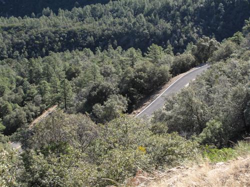
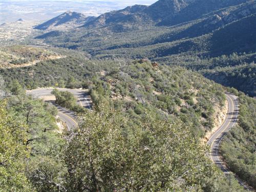


Top of pagePrevious messageNext messageBottom of page Link to this message

Scottykrein
Posted on Monday, February 09, 2009 - 11:09 am:   Edit Post Delete Post View Post/Check IP Print Post    Move Post (Custodian/Admin Only)

http://www.motorcycleroads.com/routes/SouthWest/AZ /AZ_7.shtml

This is what Google told me.
Top of pagePrevious messageNext messageBottom of page Link to this message

Mark_weiss
Posted on Monday, February 09, 2009 - 03:16 pm:   Edit Post Delete Post View Post/Check IP Print Post    Move Post (Custodian/Admin Only)

Hmmm,

10000 ft, dead ends? Sounds like Mt Lemmon.

Mark
in Arizona
Top of pagePrevious messageNext messageBottom of page Link to this message

Rotorhead
Posted on Monday, February 09, 2009 - 04:20 pm:   Edit Post Delete Post View Post/Check IP Print Post    Move Post (Custodian/Admin Only)

It dosen't dead end there's backside dirt, very seasonal "road" down the mountain into the San Pedro valley makes for a great loop back into Tuscon from the north or Benson to the south. Great ULY day trip!! Twisty up and dirt jeep trail down!!!
Top of pagePrevious messageNext messageBottom of page Link to this message

Ulynut
Posted on Monday, February 09, 2009 - 04:37 pm:   Edit Post Delete Post View Post/Check IP Print Post    Move Post (Custodian/Admin Only)

Now I have to go to AZ
Top of pagePrevious messageNext messageBottom of page Link to this message

Rotorhead
Posted on Monday, February 09, 2009 - 04:39 pm:   Edit Post Delete Post View Post/Check IP Print Post    Move Post (Custodian/Admin Only)

How 'bout another SE AZ road? It's dirt and the black line in the top right is the fence on the boarder to Mexico. The elevation hides the 2 other switchbacks.


(Message edited by rotorhead on February 09, 2009)
Top of pagePrevious messageNext messageBottom of page Link to this message

Bttrthnwrk
Posted on Monday, February 09, 2009 - 09:09 pm:   Edit Post Delete Post View Post/Check IP Print Post    Move Post (Custodian/Admin Only)

If you decide to spin and slide your way down the backside of Mt Lemmon on the dirt road, there's also about 40 miles of dirt road south and east of the mountains that curves back around into Tucson over Redington Pass, instead of south to Benson - it just depends on which way you decide to go at the fork south of San Manuel.

I can tell you that the Redington Pass road is pretty good, but the dirt bikers sure look at you funny if you're tooling along on a cruiser. And the gravel and sand switchbacks that come down out of the pass into Tucson are... interesting... on a cruiser. It's harder to steer using the throttle and back brake on a 560 pound bike that I would have thought, before I tried that.
Top of pagePrevious messageNext messageBottom of page Link to this message

Ft_bstrd
Posted on Monday, February 09, 2009 - 09:33 pm:   Edit Post Delete Post View Post/Check IP Print Post    Move Post (Custodian/Admin Only)

I think Slicker posted up about that road recently. Looks like fun.
Top of pagePrevious messageNext messageBottom of page Link to this message

Supertoon
Posted on Tuesday, February 10, 2009 - 07:46 am:   Edit Post Delete Post View Post/Check IP Print Post    Move Post (Custodian/Admin Only)

Actually it is the access road up Mt. Graham just south of Safford. I believe the rt no. is 366. Check it out on Google Earth. We went form 62 deg to 24 deg at the top. Here is a pic where we turned around. Unfortunately we ran out of time and could not do Mt Lemmon.

« Previous Next »

Add Your Message Here
Post:
Bold text Italics Underline Create a hyperlink Insert a clipart image

Username: Posting Information:
This is a private posting area. Only registered users and custodians may post messages here.
Password:
Options: Post as "Anonymous" (Valid reason required. Abusers will be exposed. If unsure, ask.)
Enable HTML code in message
Automatically activate URLs in message
Action:

Topics | Last Day | Tree View | Search | User List | Help/Instructions | Rules | Program Credits Administration